Showing posts with label New Zealand. Show all posts

Mueller Hut - there and back again

Hiking is one of my favorite pastimes and in this time of isolation from the pandemic outbreak, I've been taking a trip down memory lane and found some of my favorites. New Zealand has come up a lot, as has Argentinian Patagonia. I have written extensive posts of our trips to both countries but thought someone out there might like some more information, the nitty gritty, on how, how much, when and all that. So here we go.

Mueller Hut lies at 1800 meters above sea level in Aoraki/Mount Cook National Park on the South Island of New Zealand.  It is an out and back via the same route but that's really not a deterrent as the view are so spectacular you will probably not mind seeing them twice. 

Reservations for staying over - a lot of people just do it as a day trip - are made through the Department of Conservation's website (https://www.doc.govt.nz). Once you get to the Mount Cook Visitors Centre in Hooker Valley you simply show them the printout and you get the ticket which you present to the hut ranger. Easy. It's about $45 NZ for a bunk bed and use of the kitchen, which has gas but no cooking gear or lighters. We opted for the bunks but there is enough flat ground and fairly sheltered areas to put up a tent. If you dare. There are LOTS of keas.

The seams lasted a couple of hours...
The trail starts at Kea Point Track outside the visitors' center but can also be reached from the White Horse Hill car park. We stayed overnight at the Mount Cook Backpacker Lodge so we could get started early and were fortunate to have absolutely gorgeous weather. They only had dorms but there was a large kitchen with lots of cookware and a big dining hall overlooking the valley.

Trail conditions going towards Sealy Tarns
We were off at the crack of dawn, meeting several small groups of hikers along the way. This trail is pretty much up hill, all the way from the valley floor, sometimes along gravel trail, sometimes on wooden stairs. Being NZ, it's extremely well maintained. After many zigzags (I never count) and a couple of hours, the first "stop" is Sealy Tarns. From here there are spectacular views of Mount Aoraki/Cook and the Hooker Valley and it's a good place to have a snack and take lots of photos, even if the clouds are low hanging.


Sealy Tarns

From the tarns, the trail gets a bit more rugged and becomes more of an alpine route than a trail. We followed the orange markers through the tussocks which eventually turned into a rock scramble. It's fairly easy to figure out which way to go - up - but the boulders are large and probably not well suited for someone with weak ankles. Some people used hiking poles to provide some extra support. I went with the "hands and knees" option as I rarely use poles - for me, they get in the way of photographing - but everyone differs on this. Use whatever makes you feel safer and, if you're new to scrambling and walking on scree, remember you have a heavy backpack on that impairs your balance.

The trail gradually becomes not so much a trail

Follow the orange markers!
After about 50 meters of this, we came to the skyline ridge and amazing views of the
Mueller Glacier that swept down the valley, passing several smaller hanging glaciers along the way. You also have views of the very cool ice shelf on Mount Sefton. We were lucky with the weather and there were very few clouds.


As you round the corner, you get the first sighting of Mueller Hut and it's a stunner. And that's when it hits you - this is where we spend the night and it's going to be SO cool. I could almost feel my camera jumping for joy. The hut has a 360 degree view of the surrounding mountains and there is literally nothing preventing you from getting gorgeous pictures. As long as the weather held and it did.

A long awaited sight
Following the rocky trail those last few meters were a breeze but then odd sounds started to come into ear shot. It sounded almost like crying babies, and yet... The cry of the kea is very distinct and hard to describe.It almost makes you think of video game sound, so otherworldly and unlike anything else. And they were having fun, which explained why everything on the hut was bolted down like they expected a raid by marauding Vikings. Everything was being picked at, nibbled on, tried on for size.

Keas trying to find purchase on the metal roof
 
Attitude...
The setup was the same as with many of New Zealand's huts - a thick mattress in a couple of big mixed dorms, BYO pillow, sleeping back and ear plugs - though this one had a particularly cool long-drop...

The Mueller long drop - not a bad view
The dorm - aiming for comfort, not privacy
This particular hut sleeps only 28 so it's one of the smaller ones but there was a nice, big common room and kitchen.  None of the bunks are assigned numbers so we grabbed a couple that faced windows after checking in on the roster. There were closets opposite to store our stuff. Since I do get up to photograph sunrise, we took bottom bunks. Then it was off to eat lunch outside in the sunshine and watch the keas frolic on the roof. The area around the hut is filled with cool alpine plants and it was fun to wander around and take pictures.

The wind picked up at bit...
After a hearty re-hydrated noodle dinner, the stable of backpackers the world over, the sun started to set and people went outside to watch the light disappear. The wind had picked up and it was pretty cold as there was absolutely nothing to hold onto the warmth from the day - a windbreaker came in very handy. It was gorgeous and I stayed out until I could no longer feels my hands or hit the shutter button, then fled inside to warm up on tea and whiskey. As with the other huts we stayed in, there was a nice atmosphere. Everyone had endured the same rigors coming to the top and the sense of exhausted accomplishment was as undeniable as it was satisfying. It was a good, fun group of people, including a bunch of Aussies who had actually dragged several bottles of wine to the top. Admittedly, I felt a little envious.

Hooray moment

Sunset over Mt. Aoraki/Cook
A word of advice about dorms - there was a large group who got up at 4 a.m. to hike back and who were shining their very bright headlights on all us sleepers as they fumbled around in the dark to get their gear together. Don't be that person. Get your stuff ready before you go to bed so you can just grab everything when you get up and gear up outside the dorm away from the sleepers. It seems self-explanatory but a surprising number of people don't. Common courtesy is priceless when you sleep with a bunch of strangers. Personally, I sleep with my camera bag just above my head and a stuff sack with my clothes so it's easy to slip out of bed using the weak light from my phone to navigate in the dark and keeping the headlight where it belongs - in a pocket :). That being said, it was totally worth getting up early for the sunrise!

Sunrise from the hut
Quite a few people were up early to watch the sunrise. Once it was done and the sun was up, we headed inside to make big bowls of hot oatmeal and instant coffee. We chatted with the Aussies who were surprisingly frisky despite having downed several bottles of wine the previous night, then cleaned up, got our gear together and headed out since we had not packed a lunch. We took our time getting back down - it's always easier on the knees going up than down - and we were back at the hostel in the early afternoon where a good lunch, and a hot shower, awaited.

Post-hike lamb pie, entirely guilt-free

As always, feel free to email me at anneharaiphotography@gmail.com with questions if you plan to go the same route!

Hiking New Zealand's Gorgeous Routeburn Track


Or, as the Kiwis say, tramping. 

In 2018, Lonely Planet nominated the Routeburn Track one of the world’s most epic hikes. I heartily agree. The year before, in the fall of 2017, my husband and I completed the track and I want to do it again. It's one of New Zealand's Great Walks and straddles the national parks of Aspiring and Fiordland with some 39 kilometers of stunning mountain landscape. There is neither the breath-squelching elevations of the Andes nor the humid heat of Indonesia’s mountains to contend with, and most definitely not the hordes that the Camino de Santiago struggles with. It is unadulterated nature, raw and wild. I have been to a lot of places around the world but the Routeburn is one of the most beautiful trails I’ve ever seen. And it’s really not all that difficult if you're in reasonably good shape.

So, down to the nitty-gritty. Several months before starting I made reservations on the Department of Conservation (DOC) website. There are 4 self-catering huts along the way - Routeburn Flats, Routeburn Falls, Lake McKensie and Lake Howden - with room to camp if you decide to bring a tent instead and save some money. If you do camp you’re allowed to use the spacious kitchen facilities at the huts. The kitchens have fuel, stoves and water available at no extra charge, but you will need to bring all your cooking gear, including a lighter, and food. We paid about $50 per night per person at each hut and stayed at all four. It can be done in two overnights but if you are not in a hurry, it is most definitely worth taking the extra days. I recommend making the reservations as soon as you know when you can go since the huts only have room for about 40-60 people a night. They are very basic bunks with mattresses included. You will need to bring a sleeping bag and pillow – and probably some ear plugs or headphones. A lot of snoring going on with that many folks in one room.


Last time being clean for 5 days!
Once you get to Queenstown you'll have to visit the DOC's office with your reservation papers to get the official tickets. We got four so we could give one to the ranger at each hut. The track starts outside of Queenstown at Routeburn Shelter where an easy shuttle ride can deposit you at the trail head. We had rented a car since we were driving all around the South Island and instead made arrangements with a car relocation company (Tracknet.net) to pick it up at the Shelter and drop it off at the Divide where the track ends. It was an option that saved us from having to take the shuttle bus all the way from Te Anau at the Divide and back to Routeburn Shelter. It was a bit more expensive than the shuttle but not by much and it saved valuable vacation time that would have otherwise been spent backtracking.
Close encounter with a tomtit

Routeburn Flats hut


Giant southern beech in forest near the Flats, also known as Fangorn
The walk from the Shelter to the first hut, Routeburn Flats, is about 6.5 km and takes only a couple of hours. It is ripe with vistas of New Zealand’s iconic beech forests and cascading streams, all of which are bridged. Look out for birds, if you love wildlife, as there are lots of tomtits, tui and fantails. Once we reached the hut, situated in the outskirts of the flats and overlooking the snowy peak of Mount Somnus, we spotted some paradise ducks. As dusk approached a gang of keas descended to pick apart any hiking shoes left outside the hut – nature’s very own entertainment. These mountain parrots, indigenous to New Zealand and found nowhere else, are some of the smartest birds in the world and are not deterred by such paltry things like rubber seals. They spent most of our dinnertime noisily picking at the ones fitted around the hut’s skylight. Apparently, they had had to be replaced several times. It was great to sit and watch them with a really nice couple from Auckland that we had met along the trail.

The naughty nighttime keas
Day two‘s walk is only about 1.5 hours, ascending about 275 meters to Routeburn Falls. The trees are still present but grow gnarly and significantly lower. Right behind the hut are the Falls which, since it had recently rained, were pure torrents. A bit further up is a more luxurious hut owned by a company that caters to your every whim and priced accordingly. The Routeburn Falls hut overlooks the whole valley. 


The next morning it rained torrents and resulted in a crazy amount of impromptu waterfalls cascading down all the valley walls as we sat outside on the veranda, wondering if we would be hiking in the rain and listening for each booming crack of thunder that made the mountains tremble. 
 
Ranger gives a lecture in Routeburn Falls hut while we waited for the rain to subside
The wind swept the rain up the mountainside!
The resident ranger, infallibly confident, assured us it was quite normal and would stop by the time we had to leave and make room for the next set of incoming hikers. He was right. Like clockwork, at precisely 9:15 am, it stopped, the sun burst through the thick clouds and the world seemed greener than ever. The falls had doubled in size in a matter of hours. So on we went, past the cascades and into the alpine tussock grasslands beyond. Trees were replaced with phormiums and an abundance of high-altitude wildflowers as the land rose another 300 meters and the track meandered over boggy meadow to the highest point on the track.

After the rain and waiting to head out

Routeburn Falls - after a night of rain
Track leading away from the Falls hut
Harris Saddle sits at a comfortable 1225 meters above beautiful Harris Lake and is reached after overnighting at the Routeburn Falls hut. Saddle has an emergency shelter so you are not allowed to overnight and there are no bunks, but it is a great place to take a break and enjoy a well-deserved lunch. It does have a long-drop toilet. It also overlooks the other side of the track and the Serpentine Range.
Approaching Harris Saddle shelter

At the shelter - and a mighty fine view of the Serpentines
After Harris, the track continues along the Hollyford face around to Ocean Peak corner and from there on the trail gets a little rougher, with some gentle scrambling required as it descends steeply in zigzags into the valley towards Lake Mackenzie. 


At the lake is the third hut, not surprisingly named Lake Mackenzie Hut. Take a load of  - when we got there, the ranger gave an excellent lecture on the fragility of the valley’s ecosystem and the destructive menace, the stoat (imported from England) that has had a devastating effect on New Zealand’s many ground-nesting birds. He told us to pay close attention to the difference between the amount of birds on the stretch of track we had already covered and what we would be seeing on the stretch tomorrow. He was not wrong – the density of wildlife was seriously increased and really highlighted the conservation efforts in the valley. It was as though someone had suddenly turned up the volume! We even saw some parrots and keas.

The tiny building to the far right - Mackenzie Hut

Mackenzie hut
The next day we again started off soon after breakfast, our packs a bit lighter as we only had one more night ahead. I have to admit I wished the track was a lot longer at this point. We had so much fun with the people we kept bunking with at the huts and doing the occasional stretch of walking with. During this stretch we climbed a bit, then entered a grassy area abundant with ribbonwood trees and past Earland Falls. The falls were spectacular, some 174 meters tall. The trail is pretty close to the water and getting sprayed was not optional. Did I mention that apart from that one night of rain, the weather was perfect?
Earland Falls

The tracks gradually descended to the fourth hut, which sits on the shores of Lake Howden. As the afternoon wore on, people were jumping in the lake though I chose to meander around shooting birds. The vegetation had changed from high alpine to more grass and low shrub terrain, equally beautiful. On the last night we heard another short talk by the on-site ranger on the biodiversity of the Southern Alps as clothes hung drying around the fireplace and we sat sipping the last of our hot chocolate and whiskey. There was a really nice sense of camaraderie, everyone enjoying the trip and each other’s company. We met a frisky pair of Aussie ladies in their early 70s who told us they had walked the Australian Outback last year which had taken something like 4 weeks and several air drops of food and beer. Just goes to show age is no hindrance – I want to be just like them when I grow up!
Lake Howden Hut

Sunset at Lake Howden
The next morning, after a good night’s sleep with ear plugs, we had our last breakfast and did the usual exchange of emails with our new friends from Auckland with promises that if we ever found ourselves on the North Island, we’d be stopping by for sure. I hope we do. The hike out to the Divide highway was about 12 km and was pretty forested most of the way as we descended a bit out of the valleys. As we got closer to the trailhead, we started encountering day trippers and boy, did they smell good! Perfume, deodorant… things we had been, eh, lacking in for the past four days, not to mention most of them were freshly showered…


At last the trail spilled into a small graveled parking lot where, lo and behold, the nice folks at Tracknet had deposited our car. It was like magic! I grabbed the long-awaited bottle of local red out of the trunk and we toasted our success, cups unnecessary! Moments later our Auckland friends emerged from the woods and we hugged and took pics. They were headed back home whereas our adventure would continue south to Te Anau and, hopefully, a really, really long shower.


Mission accomplished!
The Routeburn was a mindblowingly beautiful experience and I would go back and do it all over again, any day. Really. Any day. Because the problem with New Zealand is that the moment you leave, you probably can’t wait to get back.  It’s just that nice.

Stinky but happy - and ready to go again
NEW ZEALAND


I once saw an article on a trail called the Routeburn Track in a travel magazine. It was a 4-5 day long trek across the southern alps of New Zealand and seemingly one of those “once in a lifetime” deals that, according to the author, left you wanting to come back again and again and do all the other tracks and stay in all the amazing huts along the way. Now that I’ve done it I can only agree. The moment I left New Zealand, I couldn’t wait to get back. I’ve become a hut-bagger.


We left in February 2016, so early fall Downunder, and started with a few days acclimatizing to Kiwi culture in Christchurch. Not that long before, the city had been hit by a severe earthquake that had devastated many of the older buildings and, since many of the developers were still fighting with their insurance companies, a sense of quite resignation still presided over what must have been a busy place before. Ever the innovative Kiwis, however, some of the restaurants that had been damaged in the quake had reopened but were now housed in remodeled and very quake-proof shipping containers. We visited the beautiful and extensive botanical garden, took the Christchurch Gondola to the top of Port Hill, and stayed in a nice little hostel near the city center. 

View from gondola near Christchurch

Lunch at Travis Wetland


If the budget allows, I recommend getting a car in New Zealand. Towns on the south island can be few and far between but, more importantly, you will want to stop every 10 miles to take pictures! New Zealand is as varied and exciting as it is beautiful. The people are kind and welcoming and the driving is easy, once you get used to doing it on the left side.
Traffic jam - Kiwi style
From Christchurch we started inland towards Arthur’s Pass with the goal of eventually landing on the west coast. The drive meandered over rolling hills and farmlands, and fortunately passed by many small coffee houses selling some truly exquisite meat pies. After stocking up on road trip food at Sheffield Pie Shop's heavenly lamb pies and seeing the giant pink donut that had been erected for a Simpson’s event, we stopped at Castle Hill and had a nice hike to the odd rock formations.


The drive across Artur’s Pass landed us on the West Coast at Kumara Junction from where we headed south and made a stop for lunch on the beach in Hokitika, a funky little seaside town that hosts a driftwood sculpture festival every January and still had a number of leftover pieces on the sand. 


We continued along the coast, passing marshes and wetlands and very few other cars, and ended at the small town of Franz Josef. The town is aptly named for the nearby 7.5 mile long Franz Josef  Glacier (Māori name is Kā Roimata o Hine Hukatere), located in the Westland Tai Poutini National Park, which descends from the Southern Alps to less than 980 feet above sea level. Quite an unusual sight to see a glacier from a temperate rain forest.
We checked into Sir Cedric’s Chateau, a nice little backpacker hostel in the center of town. The hostel has good connections with several tour companies that run walking and helicopter trips to the glacier. Since it was my birthday the following day, we decided to splurge on a helicopter and glacier walk trip with Franz Josef Glacier Guides – after all, how often do you get to spend your birthday on a glacier in New Zealand? Once in a lifetime experience - check! We opted for the tour that let you spend the longest time on the ice as well, oddly not the most expensive one. Since we had the afternoon free, we went on a short hike across the river that forms the outlet of the glacier with view of the ice in the distance and there were also a couple of nice forest walks in that area. The main street is pleasant, has a number of small tourist shops and some good restaurants.


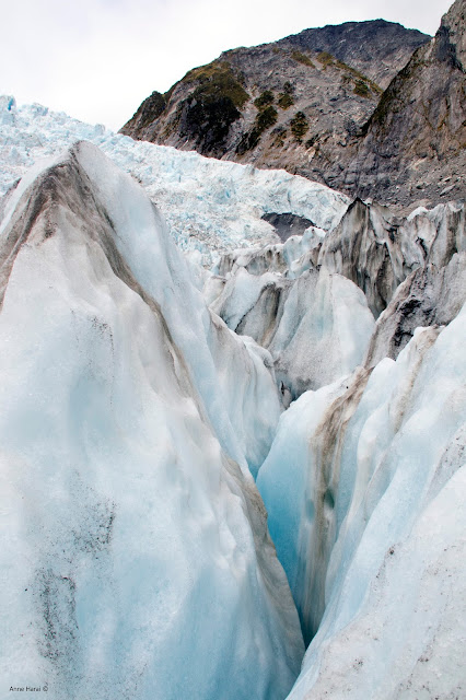
The tour was amazing. I’ve never flown in a helicopter before and, since I was the smallest passenger, I got to sit next to the pilot. Awesome! He flew the length of the glacier, bottom to top, and landed up about ¾ of the way up in the middle of the ice on a small section just big enough for a single helicopter. Our guide explained about the dangers and precautions to take on the ice. We were outfitted with jackets and pants that made us easily recognizable to the guides, and emergency kits and poles. The ice of a glacier shifts all the time and at times the guide had to dig in new steps since the previous day’s steps were already unusable. We spent a good two hours on the ice and saw the occasional piece break off with a resounding crash, and it still felt like it was over too soon. What an amazing experience.

The last day in Franz Josef we rented a kayak from Okarito Nature Tours and spent half the day paddling around Okarito lagoon. It was beautiful and frequented by an abundance of wading and marshland birds. I’d highly recommend this trip for anyone who likes kayaking and/or birds. They rent for half and full day at a very reasonable price.


It was time to continue on the southbound journey. We passed Fox Glacier a bit outside Franz Josef and were able to take a few pictures from afar, made a brief stop for a short hike in Haast to the blue pools but the trail had been washed out and closed. We 
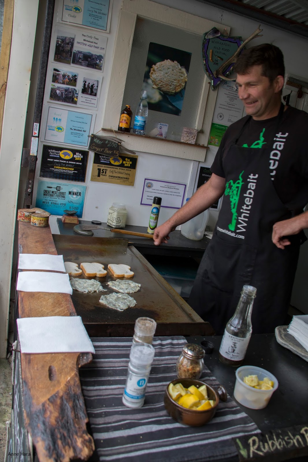
did, however, stop outside of Haast for a taste of the famous whitebait-on-toast...


White Bait - Queen of Tiny Delicious Fishes

The road headed inland then and into the Southern Alps where sheep dotted the hillsides and were eventually replaced with mountain lakes and steep slopes. Lake Wanaka and Lake Hawea are the largest and we made a quick stop in Wanaka for meat pie lunch. A second stop at Queenstown Hill had great views of the mountains and our first peak of the town itself far below.


We arrived in Queenstown, adventure capital of the South Island, and checked into Sir Cedric’s Bungi Backpackers. Good place with very nice people in a quiet neighborhood about 10-15 min walk from the pier, where most of the restaurants and tourist shops are located. Our primary goal for Queenstown was that it is the hub for starting the Routeburn Track. Since I had already made reservations for the four huts along the route, all we had to do was pick up the permit at the Department of Conservation office in town. The DOC might well be the most well organized government office in the world – they are in charge of creating and maintaining the majority of New Zealand’s trails and wilderness huts and are doing an absolutely stellar job, in addition to being the primary authority on eradication of non-native species vermin, i.e. the scores of stoats and rats that continue to decimate the country’s native birds. I cannot say enough good things about this organization. The fee for staying in the huts goes to the conservation program, trail maintenance and hut upkeep – all good things.


Queenstown is a busy tourist and backpacker hub for all things adventure. Leaving the bungy jumping to the younger crowd, we instead took the gondola to the Skyline complex  overlooking Lake Wakatipu and the Remarkables range and did the Lower Ridge Hike. The views were spectacular and the restaurant that’s part of the Skyline outfit is pretty good.
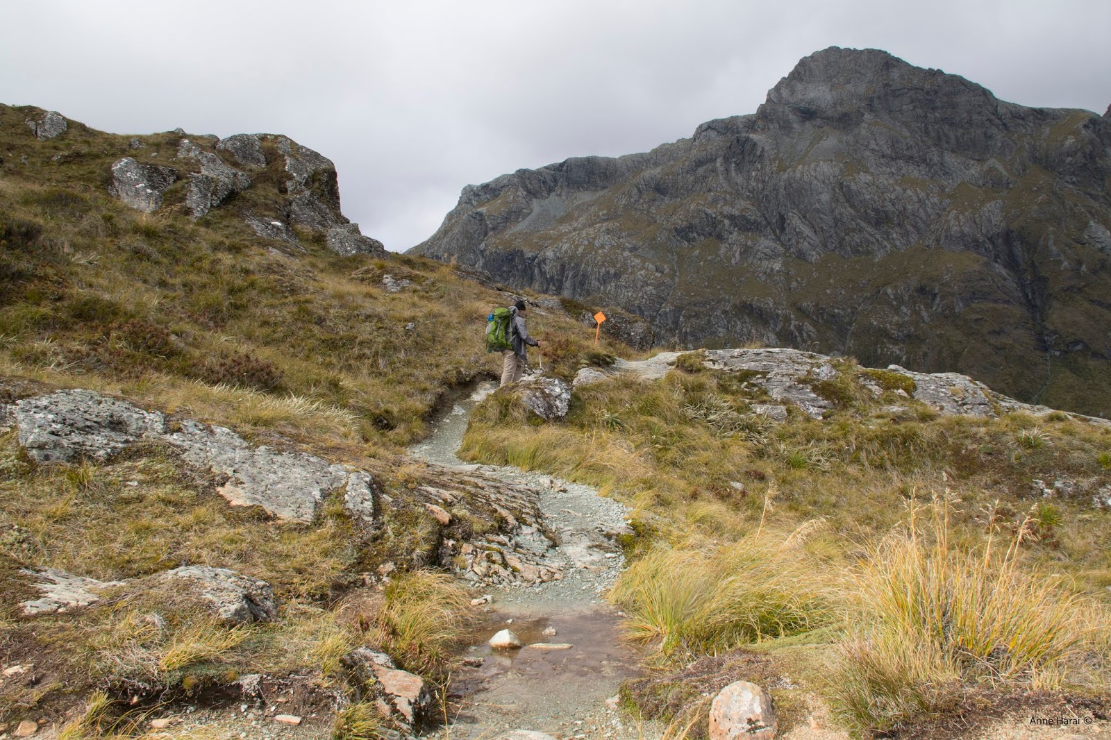
The Routeburn Track starts at Routeburn Shelter. We had made arrangements with Easy Hike Car Relocation to relocate our car so it would be waiting for us on the other side of the mountains. It was not cheap, about $260 NZ, but actually came out to about the same if we took the shuttle service and also did not waste a whole day of back-tracking so it was totally worth it. The track itself was spectacular. It passes through several climate and vegetation zones so there was always something new to discover. Some sections were easier than others and the weather turned a bit at Harris Saddle one evening, aka torrents of rain that created new waterfalls down the mountainsides (it was fantastic to watch from the shelter of the MacKenzie Falls hut), but the following morning the sun was out again. All the huts were outfitted with bunk beds and mattresses and the kitchen had gas stoves so we just had to bring sleeping bags and cooking gear (and matches - they are not self-lighting). No food was available en route or at the huts but that was easy enough to carry, and there was a ranger at each hut to answer any questions and check us in. They also gave some very informative lectures on the conservation program. We made several good friends and met the most amazing people, including a 75 year old Kiwi lady, who had done the track five times!
Enough words about how amazing this trek was – the pictures say it all :)

While we were still clean...


Picnic shelter at Harris Saddle

Having crossed the saddle
It was a bit of an eye opener to encounter the native Kea, a chicken sized mountain parrot that will molest anything not tied down, and some that is. I had read about them but seeing them in action was sheer delight. On the first night they were trying to unwind the weather stripping on the hut’s skylight and when that didn’t work, they went for the hiking poles and boots left outside. After that first day, nothing was left to chance…


Lake MacKenzie hut
Five days later, and in need of a good scrubbing, we came out on the other side where our car was waiting. Then it was on to see Milford Sound and lunch at the little cafe.

Sunset at Howden Hut
 
Milford Sound on a rather cloudy day
I had booked a hostel in Te Anau, which came with a shower and a cat we named Fluffy. It's a quite little town and the jumping off point to a glow worm cave. We did a boat tour the next day to the cave, where you are obviously not allowed to take pictures but it was very neat to see the threads of glow worm slime draped across the cave ceiling like Christmas garlands. Te Anau also has a bird sanctuary sporting the rare flightless takahē, also prominently features as the town mascot...

The real bird

The fake bird
We did a section of the Kepler Track, because we just hadn't done enough hiking lately, before heading south to sleepy Tuatapere. Even smaller than Te Anau, Tuatapere's claim to fame is being the Sausage Capital of the South Island and I'd have to agree. The restaurant at the Last Light Lodge where we also stayed in motel-like accommodations had the best venison sausage I've ever had, putting a whole new spin on bangers n' mash.

 Chilling at Last Light Lodge where all the food was superb


Hiking in Bluff
On our last day in Tuatapere we drove south and hiked a section of the Hump Ridge Track that runs along the ocean, then continued the journey to Bluff. We overnighted at the Bluff Lodge, a quirky old place, and took the ferry to Stewart Island the following morning. Fortunately the ocean was completely calm and the crossing was lovely - rumors have it it's a brutal trip if it's windy!

Bluff wall art
 

Stewart Island is a pretty amazing place. The main town is Oban, which has a handful of good restaurants - one being Kai Kart where the fried blue cod sandwiches are to die for.


It's a pretty walkable island. Since it was still early in the day, we walked to Golden Bay and took the tiny ferry to Ulva Island for a 3 hour guided birding tour. Ulva is tiny but is unique in that it has an abundance of birds on account of it being rid of stoats and rats. There were birds everywhere, though some were hard to see, but the guide was quick to find and name them.


                                                             NZ Parakeet
Bit of a sleeping morepork owl
Oban has a little grocery store, where you can get the essentials - nice to be in hostels with kitchens. We ended up having dinner and some pints at the South Sea Hotel, fanciest place in town and full of locals eager to chat. The food was really good,too. We could have gone back to the hostel then, but I had heard a rumor that little blue penguins, or fairy penguins, occasionally come up to the shore near the harbor as the sun sets... so camera & tripod in hand we settled down to wait. Dusk came - and the rumors were true!


The next day we did a nice hike along the water that ended up at Horseshoe Bay. The water was so blue it felt like a tropical island despite it's very southern location (about 2500 km from Antarctica). We stopped at Moturau Garden on the way back, which has a nice collection of native trees and plants but based on British garden design.


Stewart Island sunset
The following day we left the island, after having seen the penguin the night before again, and picked up the car in Bluff. Next stop was Waipapa Lighthouse. It was very pretty but the best part was the undoubtedly the fur seals. Bit of a fight between a young and an old male over a female (naturally). It was quite a thing to see.

While things were still dignified...
And then the other male arrived

The old one won in the end and we moved on, leaving the couple in peace. Next stop along the south coast was Curio Beach and then Porpoise Beach to see the petrified logs that reach far into the ocean and have lunch.


Overnighting at Tautuku Forest Cabin in the Catlins.
The following day we headed for Dunedin but made a long stop to hike to Nugget Point lighthouse. It actually felt a bit like being back in Ireland, rugged cliffs and all. It's a nice little hike to the lighthouse with stunning views of the ocean and fur seal far below sleeping on the cliff terraces.


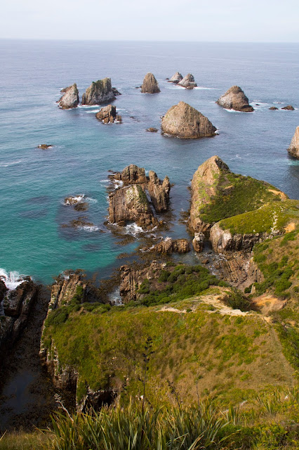
The aptly named Nuggets


The ever-present and usually sleeping fur seals
Dunedin is a lovely town originally settled by Scots, quite evident in the architecture. We visited long lost relatives on my husband's side of the family, who took us around town to see, among other things, the local stadium and Speights for lunch. Speights is the local claim-to-fame beer and is very good. We had already booked accommodations at Penguin Place on the end of the Otago Peninsula, which is a penguin conservation center for the yellow-eyed penguin - and a photographer's paradise.


                                                Dunedin train station


Also on the Otago Peninsula is the Albatross Center but unfortunately it was too foggy to see the birds. Instead we took a dusk tour from the Center to see the little blue or fairy penguins (eudyptula minor) and were not disappointed as they came hopping out of the ocean with nightfall.


The following day we did an early morning tour from Penguin Place of the yellow-eyed penguins (megadyptes antipodes) or hoiho in Maori, walking through bunkers to hide our size (when they can only see half your face, they are not scared since they think you're really small). It was thrilling to see them close up and, unlike the fairy penguins, they prefer daylight. The afternoon was spent wandering the beautiful English gardens around Larnach Castle.


Young female yellow-eyed penguin

Fjordland penguin at Penguin Place
Dunedin is full of art and very fond of penguins.


On the last day on the peninsula, we took the Taieri Gorge Rail Tour to Pukerangi aboard a beautiful old train. The trip meanders along on rickety rails with great views of the gorge and Taieri River far below.


From Dunedin we drove north to see the Moeraki Boulders. Maori legends say the boulders are the remains of eel baskets that were washed ashore from the wreck of a large sailing canoe; geologists say they are septarian concretions exhumed from the mudstone enclosing them and concentrated on the beach by coastal erosion. Whichever you chose to believe, they are a sight to see.


Our last stop was Mt. Cook. The drive alone was worth it but even better was our hike up to Mueller Hut. The town is sort of an adventure village set in Aoraki Mount Cook National Park and houses a large hostel and a number of chalets. Mt. Cook is the highest peak in New Zealand and where Sir Edmund Hillary trained for his climbing of Everest. It's a beautiful setting in any event with lots of trails and, most importantly, a chance to bag Mueller Hut.


For the bargain price of about $30 NZ, you get to scale the Sealy Range and overnight at the 36 bunk bed hut, elevation 1800 meters, and enjoy views of ice cliffs, glaciers and the spectacular rock that is Mt. Cook. Fabulous, had to do this. I had made reservations as space is limited, and after having spent the afternoon and evening checking out the area, picking up our permit from the DOC office, and cooking lamb in the communal kitchen of the hostel, we awoke to clear skies. In other words, a perfect day to scale a mountain!


Midway point - time for pics and lunch

And the trail is where...?

Made it!

The remotely located hut

Kea paparazzi


The bathroom
The luxurious overnight accommodations :)


       Tent? Not a good idea. This bunch was systematically picking apart the seams all through the evening.

Sunset over Mt. Cook

and not a bad sunrise either.


          Leaving the park and heading homewards...

... after just one more lamb pie!

Time to go home and start saving up for the next one. Hope you enjoyed the journey!

If you're planning a trip to NZ and have questions I can possibly answer, feel free to email me or comment on this post.
Itinerary and hostels:
Christchurch – Foley Towers
Franz Josef – Sir Cedric’s Chateau
Queenstown – Sir Cedric’s Bungi Backpackers
Routeburn Track:
http://www.doc.govt.nz/parks-and-recreation/places-to-go/fiordland/places/fiordland-national-park/things-to-do/tracks/routeburn-track/
Te Anau – Te Anau Backpackers
Tuatapere – Last Light Lodge
Bluff – Bluff Lodge
Steward Island – Stewart Island Backpackers
Catlins - Tautuku Forest Cabins on Lenz Reserve
Otaga – Penguin Place
Aoraki Mt. Cook NP – Mt. Cook Backpacker Lodge & Mueller Hut