I have flown through Iceland more times than I can count, every time in December with a brief two hour layover on the way to see my family in Denmark. Always an ice-locked winter wonderland at that time of the year, with sunlight so brief it barely had time to register, it was still enough to make me wonder if a longer stay, in the summer, would be worth the while. So when my friend Lars suggested backpacking the Laugavegur and Fimmvorduhals trails with Jen and I, I immediately said yes, without a second thought as to logistics. I'm rubbish at running but good at walking far so this was absolutely something I wanted to tackle. A quick internet search for images promised volcanoes, glaciers, endless stretches of desolate lava fields, raging rivers fed by a hundred waterfalls. And wild-roaming sheep. Oh, hell yes.
We landed in early August and the weather was, well, not ideal but the sun did poke out on occasion and it was about as warm as it would ever get. The locals were saying it was time to start preparing for winter. The midnight sun, while still up very late, was starting to decline and make its long route to the dark days. Summer is brief in Iceland.
We stayed in Reykjavik for a couple of days, at a lovely hostel called Baldursbra (Balder's Gate), and not very far from the city center. I quickly realized that despite knowing no Icelandic, I was able to interpret a lot of the written language due to being Danish. What luck! We spent a bit of time getting to know the capital, full of architectural marvels and quaint restaurants serving up very local fare. We sampled a number of tasty local brews, and some seriously good cocktails made with Icelandic thyme and other botanicals gathered off the wild land and expertly distilled into some of the world's best gin. Even before I made a longer stopover, I was buying a bottle of gin at the airport en route home to Seattle every year. This is some classy stuff if you, like me, are a gin fan.
.jpg)

.jpg)
.jpg)
After a couple of days, and having planned our route to include the extension that is the Fimmvorduhals trail, we were looking at some 54 miles of hiking over 4 nights. The elevation was not much to speak of. We had a lot of strenuous uphills ahead and possibly some rough trail, but nothing above 6,000 feet. And we had everything we needed - tents, pads, sleeping bags. The usual suspects. There were huts along the route but we wanted to camp and feel the rock beneath our feet and the wind flapping the tent with everything it had to offer. Extreme weather can be fun, as long as you are well prepared. We had meals for 5 days, some to share and some to spare, and some of the huts were said to offer the occasional cookie.
There is a shuttle that will take you all the way to the trailhead in the north, some 4 hours from Reykjavik and it was a beautiful drive, especially when it turned off the main road at a sign saying 'unpaved road.' After a couple of hours of rattling on gravel and fording a river or two, we ended at the geothermally active Landmannalaugar Natural Reserve where we signed in, took the obligatory picture under the trail sign, and then started the relatively short 7 mile hike to the first camp, first through the undulating lava fields of Laugahraun and then past the beautiful Brennisteinsalda. We took an early lunch to enjoy the view of the rhyolite mountains. It was truly otherworldly. Another uphill brought us to Stórihver, a green valley filled with steam vents from one of the many geysers.


The approach to the first hut, Hrafntinnusker, is up a somewhat steep obsidian incline but once we hit the top, the trail led down the hut which sits at the highest point on the trail at about 1,100 meters. It looked very small in the long valley. Undulating lava hills, striated with the remnants of winter snow, stretched as far as the eye could see until the clouds rolled in with furious speed and covered everything but the bright red roof. Stone walls were set up for tent placement and we quickly created a tight little circle. The weather turned very cold and misty, necessitating dinner in the vestibules. We crossed fingers for a sunny morning...
And it came, setting the weather for the rest of the trip.

After a solid oatmeal and coffee breakfast we were off again, across the basalt fields beneath Reykjafjoll Mountain. We came across several snow crossings and plenty of ravines but it was late in the season and the ice bridges had already melted. We crossed the plateau of Jökultungur from where we could see the three glaciers of Tindfjallajökull, Eyjafjallajökull and Mýrdalsjökull.


By noon, we reached Álftavatn Valley (above) and its hut. We had decided to hike a long day, so we just had lunch overlooking the lake and headed on in the early afternoon for an 18-mile day. I'd highly recommend this long day since it enabled us to do a shorter last day. Worth it!
And then the water crossings began in earnest. We soon became very adept at the shoes and socks off, cross in freezing water, dry feet, shoes back on, rinse and repeat routine. Refreshing, to say the least.

Again and again, the landscape changed. After crossing the rather deep Bratthálskvísl river, we walked along Brattháls ridge on the way to Hvanngil, a volcanic valley dotted with bright green hills and myriads of wildflowers.


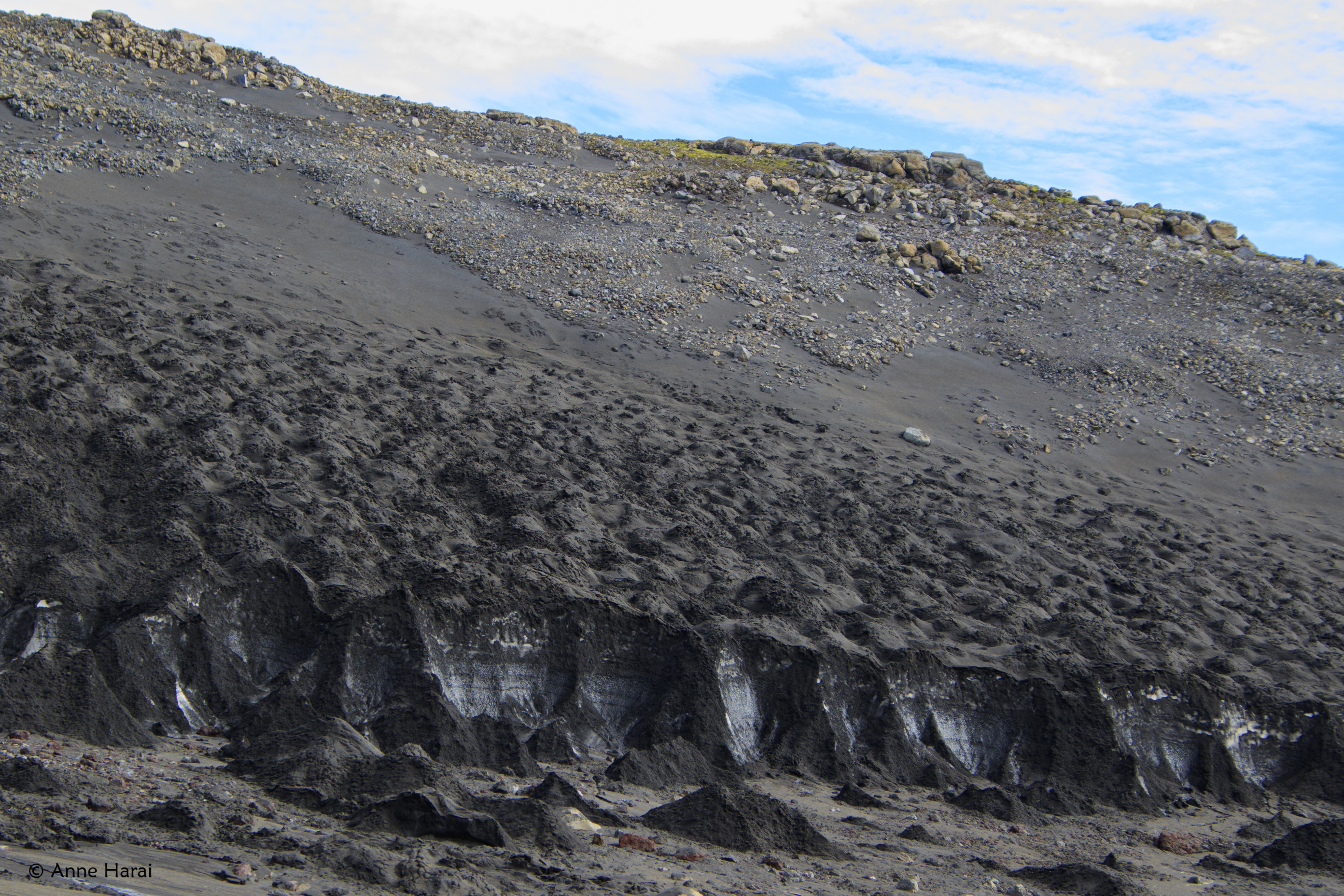
As we went further south towards Emstrur, our rest for the night, the green valley soon gave way to the black desert of Mælifellssandur, sparse with vegetation and one of my favorite sections of the trail. After cresting a black hill, we descended into a small valley and caught sight of the Emstrur hut. It was pretty busy with other hikers but we found a spot on the tip of a peninsula with amazing views to the northwest of the Myrdalsjokull glacier.


Once the river was crossed, we ascended into a couple of ravines and came into the gentler landscape of Almenningar. There was a final steep climb of the day up to the barren summit of Kápa, another and final river crossing. This spilled us out onto the gravel washout plain of the Þröngá and we entered into Þórsmörk (Thor’s Valley). Here, the land quickly became greener, with an actual woodland of birch and stunted shrubs. After descending down through the valley for about half an hour, we arrived at the hut. Þórsmörk is the end of the trail for many people and transport leaves from there to return to Reykvavik, but we were going on and just ended up having a snack on the lawn overlooking the wide Krossá river.


On the opposite side of the river was another set of buildings and we ended up overnighting at the Básar campground after crossing the Krossá river via a very nifty moveable bridge. Despite being fairly low elevation, it was our coldest night yet, with frost covering the ground in the morning. There was a little shop, where we got cookies and chocolate, and pleasantly warm showers were also on the menu.

The next morning we were off for the 8 mile stretch towards the Baldvinsskálihut, a very small hut mounted atop a hill with views all the way to the sea. We could have stayed at the Fimmvörðuskáli hut but the river to get there was very high, so we moved on and felt we had made the right choice.
Along the way we kept hearing tales of a terrible rope/chain walk but I feel like it was overstated and not nearly as scary as people would have you think. The terrain had again grown mountainous, with a layer of green like velvet interspersed with slips of black rock.


After this rise, the trail gradually descended again and led across the lava field created by the volcano under Eyjafjallajökull during its 2010 eruption. The opposite glacier is Mýrdalsjökull. We had to cross a couple of ice fields near the Fimmvörðuskáli, with a steep and very icy descent and corresponding ice climb on the opposing side. Poles came in very handy!


We reached the hut by early afternoon, as usual having taken our time to take lots of pictures, and were met by a nice warden and her very cute dog.


The hut was empty when we got there so Jen and I decided to splurge and take a night indoors. The wind was picking up but Lars went with the great outdoors, pitching his tent in lee of the hut. In retrospect, the tent would have been better since a noisy group arrived a bit after. Oh, well.
After more oatmeal and coffee the following morning, our last day saw us hiking along the Skógafos, across a relatively flat landscape of increasing green and losing count of the endless waterfalls. It was beautiful and surreal, the silence of the trail interspersed with roaring turbulence every time the path took us near the river. Towards the end, we started meeting clusters of unwelcome day hikers, signalling that our amazing hike was nearing the final stretch.


A job well done!

Our trusty rental steed- and just one more waterfall on the way to beautiful little Vik.

And speaking of Vik...


Iceland. Pure Magic.
:)